March 3-4, 2021
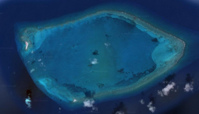
On our way from Acklins Island to Inagua to check out of the Bahamas, we had a detour to make. It would take us 10 miles out of our way (upwind, of course), but it will be our last chance to visit an actual atoll until we make it to the south Pacific. This atoll is at least 40 miles from any other islands, and is basically a mountain in the middle of 5 thousand feet of water. The reef is roughly circular, about three miles across at the widest. Most of the reef is a few feet underwater, but you do see big waves breaking on it, and there are two tiny islands. When we saw a window of light but sailable wind, totally dying away overnight, we made a last minute decision to go for it. It was just over 40 miles, and it was vital we get there before dark, so we upped anchor right after sunrise. We needn’t have worried, as we made great time in spite of the light wind.
There is a small break in the reef where you can sail into the central lagoon, with the ring of reef all around you. On either side of the entrance is a tiny island, just barely above the water. One has a stone marker on it, so you can see it a mile out. Otherwise, with everything so low, you wouldn’t get a visual until you were practically on top of it. There are two other, less intentional markers. One is a big Liberty ship that saw service in World War II, but didn’t get around to crashing on the reef until the late 1960s. It is rusted and falling apart, nearly unrecognizable as a ship, but visible for miles. The most recent pictures we could find of it were from 2013, and it’s much more disintegrated now. The other wreck, on the opposite side of the reef, is a smaller cargo ship that wrecked much more recently – the 1990’s I believe. Jeff and I would like to know more of that story, because those guys probably had charts and GPS. It takes a certain amount of skill to get her going just the right speed to get all the way up on top of the reef, but not so much speed that you’d fall off into the middle. How did they do that? Anyway, it was very cool to look at.

We dropped the hook right in the center, in 25 ft of water. That’s basically the depth of the whole circle. We had a romantic dinner and enjoyed a great sunset. That night was tough though. The wind died as predicted, but the waves and swell never did. It was so rolly we struggled to sleep. Jeff and planned to stay and dive the wrecks, but I had to play the admiral card. Even if the boat could handle the rolling another night, I could not. Jeff was pretty disappointed I think, but didn’t put up much of a fight. Come to think of it, I didn’t hear any snoring from his side of the bed last night. I think we both agreed leaving was the right call. Even launching the dinghy would have been a challenge. So we did our classic “quick tour of the parking lot” (pulling up to each of the wrecks until we risked joining them on the reef) and glided between the sandbars out into the deep ocean. In fairness, we did not even come close to going aground, and it probably had nothing to do with my steady stream of “please, slow down, that’s close enough, don’t those wrecks scare you at all!?!)
We had a great sail down to Inagua, over 45 miles in less than 6 hours, and not hard on the wind for once. Delightful. We pulled around the corner from Mathews Town, to tuck up behind Molasses Reef for a calm night. Phew!