January 15-17, 2021
After Jeff checked us into Bimini on the morning of the 15th, we repositioned to the north end of Bimini because the wind was going to shift and our southern anchorage wouldn’t be protected anymore. We sailed a delightful beam reach in light wind for a couple hours and the sun even made an appearance. It felt like the Bahamas trip was finally getting started. The north end of Bimini was a good place to begin the trip due east across to the Berry Islands.
Our plan for the crossing, because we wouldn’t be able to do the whole trip in daylight hours, was to stop half way, and anchor overnight in the middle of the Great Bahama Bank. As they say, cruiser’s plans are written in sand at low tide. Here’s what really happened:
Ship’s Log:
Distance ~75 miles
Time: 10 hours total, 8 hours sails soaring, 2 hours engine roaring
Sailing Speeds: Min 5 knots, max 9.6 knots, average 8 knots!!
Anchor up: 9AM (we were only going 30 miles to the Mackie Shoals, so no reason to set the alarm)
Anchor down: 7:20PM (surprise, it went down on the north end of Great Harbour Cay – twice as far as planned)
Wind: 15 -27 knots, avg 21 knots out of the west, with 3-5ft swells on the port quarter
Sails reefed
Maneuvers: Only 2 jibes the whole day!
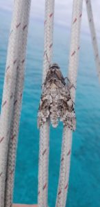
Great sail. Within an hour of leaving, half a dozen large Atlantic dolphins were playing with us, darting back and forth under our bow. As soon as we brought out the camera, they were gone. They hate the paparazzi. We did have one passenger for the trip, a big gray moth.
We saw the best speeds ever sailing downwind, with a slight ocean current and the waves pushing us along with the sails. The wind stayed high and we made the shoals by lunchtime. Jeff called an audible, and we kept blasting along for Great Harbour Cay. The wind held until we were just two hours out, and after a steady 8+knots, we couldn’t stand “just” 5.5 knots (totally normal, acceptable downwind speed for a sailboat) and motored the rest of the way. The sun was just setting, and we didn’t want to get to the anchorage too late.
Our anchorage is one we wouldn’t have chosen in pre COVID times. Just north of Great Harbour Cay there are two private islands, Little and Great Stirrup Cay, owned by Royal Caribbean and Norweigan cruise lines, respectively. These are islands where they disgorge 4 thousand passengers at a time, to enjoy the beach, and the theme park like amenities they have built up. I can see a giant waterslide on one of the Cays as I write this. The anchorage we chose would normally be swarming with ship’s tenders, jet skis, parasailers, etc. Today it is very quiet. There is a tiny sailboat anchored on the other side of the harbor, and a motorboat drove thru during breakfast. That’s all.
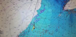
On our way over, we saw we were in cruise line territory as we sailed right along a 20 mile line of cruise ships – I counted 12 on the chart plotter at one point. The most common size was 951ft long and 100 ft wide. One ship listed it’s length as .175 nm. When the units switch to nautical miles for the length of the boat, you know it’s not little! We saw Carnival, Princess, Seaborne, and Royal Caribbean ships. It was really something to look at when all you can see around you is ocean. That’s the cool thing about the Bahamas bank where the water is electric blue, relatively small waves, and never very deep. The ships were 10 miles from land, in 40-50 ft of water.
We are tucked in perfectly, protected on three sides by Great Stirrup Cay, Great Harbour Cay, and tiny Goat Cay. We had a very peaceful night sleep because of this. Today it is cool and cloudy. We launched the dinghy to explore a bit and we went along the west coast of Great Harbour to try to find a plane wreck that was marked on the chart (no joy) and a “blue hole” where the depth suddenly goes from 4 ft to a hundred ft (found it). It was a little choppy but Fluffy did a great job of keeping us dry.

” Jeff called an audible” What does this mean?
That we changed plans based on new data.
Good language for Superbowl time!